
MTSU students will display their documentation of the “Geography of Hate” at two Nashville locations next week.

Jordan Brasher’s map shows the various routes that Native Americans were forced to take following passage of the Indian Removal Act of 1830. The top trail, in purple, is the one labeled the “Trail of Tears.” Click on the map above to see a larger version.
Ian Murray and Jordan Brasher will deliver their presentations at the annual Holocaust Remembrance Day commemoration at 3 p.m. Monday, April 8, in the State Senate Chambers at Legislative Plaza.
Murray and Charles Hunt Jr. will participate in videoconferences from 9 to 10 a.m. and from 10:15 to 11:15 a.m. Wednesday, April 10, at Vanderbilt University Virtual Campus, which is located at 2007 Terrace Place in Nashville.
Dr. Patricia Boda’s cartography class used geographic information systems and manual mapmaking for the “Geography of Hate” projects.
For the class, each student was required to use maps to display locations where genocide either has taken place or is taking place.
“I try to do things that will give them personal, actual real-world experience and do them some good career-wise,” said Boda, an assistant professor of geosciences.
Some individual presentations focused on Sudan, Rwanda, the Hopi Nation and hate groups in three Southern U.S. states.
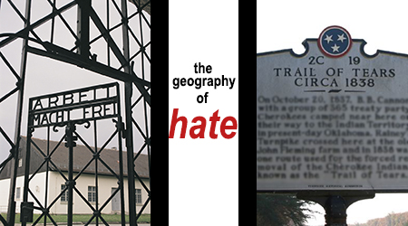
Brasher, a junior geoscience major from Milan, Tenn., chronicled the forced exodus of Native Americans from their homelands in the 1830s, a tragedy known as the “Trail of Tears.”
“I wanted to talk about the individual Cherokee removal routes and how they correlated to the death rates throughout the trip,” said Brasher, who is president of MTSU’s Geography Club. “My grandmother’s grandmother was a full-blooded Cherokee.”
Murray, a native of Spring Hill, Tenn., who graduated last fall, singled out one Holocaust survivor and traced his path through Europe during World War II.

Ian Murray’s map shows the various European locales that mark Knoxvillian Holocaust survivor Arthur Pais’ tragic trek during the years of the Third Reich. Click on the map to see a larger version.
Hunt, a geography major from Lebanon, Tenn., juxtaposes the exodus of Jews from Europe during and after World War II with the current conflict on the West Bank and Gaza Strip.
“A lot of research is being done using satellite imagery and mapping to try to identify human rights violations before they occur,” said Danielle Kahane-Kaminsky, executive director of the Tennessee Holocaust Commission.
“The research from international lawyers and people who specialize in genocide … tells us the best way we can handle this politically is through prevention,” she said.
Kahane-Kaminsky said she hopes MTSU can make a connection with the Yale University Genocide Studies Program, which she said is at the forefront of using this type of technology.
For more information, contact Boda at 615-898-2726 or pat.boda@mtsu.edu.
— Gina K. Logue (gina.logue@mtsu.edu)

COMMENTS ARE OFF THIS POST